
Measuring Distance on a Nautical Chart

Distances at sea are measured in nautical miles
- 1’ (minute) of latitude = 1 nautical mile
- 1∘ degree of Latitude = 60’ (minute) or 60 nautical miles
- Land mile = 1609m
- Nautical mile = 1852m / 1.15 land miles
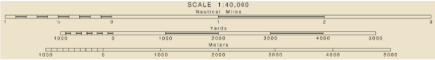
Some charts (i.e. Imray) have a ‘Scale’ on the chart but if this is not available then you will need to measure the distance from the latitude scale (side) of the chart:
The electronic way:

To measure distance on a chart plotter, typically you'll use the "Measure Distance" function, which is often found within the navigation or chart pages. You'll select a starting point, then a destination point, and the chart plotter will calculate the distance between them. Some plotters also allow you to measure distances along a route by clicking multiple points.
The traditional way:
Some charts (i.e. Imray) have a ‘Scale’ on the chart but if this is not available then you will need to measure the distance from the latitude scale (side) of the chart:
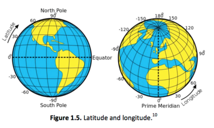
Why do we measure from the side (Latitude Scale) of the Chart?
Distances are always measuring from the Latitude Scale on the Chart NOT the Longitude Scale. As detailed in the image below, the distances between each latitude line are equal, whereas the distances between each Longitude line gets smaller as the lines approach the poles. Only at the Equator are the lines of latitude and longitude at the same distance.

How to measure distance?
Measure the distance with your dividers, parallel rules, a regular ruler or even a piece of paper!
Take that distance to the latitude scale on the chart to gather the distance in minutes.
Time Calculations:
Therefore in the example above:
3.2 n/m (Distance) ÷ 10knots (Speed) = 0.32 x 60 = 19.2 minutes (Time)
D ÷ S = T (in decimals of an hour) x 60 (to convert the decimals into minutes)
